
Permanent unique identifier for this particular organism:
http://bioimages.vanderbilt.edu/thomas/0296-01
|
|

|
|
Load database and switch to thumbnail view
Use this stable URL to link to this page:
http://bioimages.vanderbilt.edu/thomas/0296-01.htm
This particular organism is believed to have native means of establishment.
This organismal entity has the scope: multicellular organism.
Identifications:
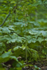
Aplectrum hyemale
(Muhl. ex Willd.) Torr.
nominal concept
common name: Adam and Eve
family: Orchidaceae
Identified 2009-05-10 by Ron Thomas
Location:
Hollow leading to field of Tomahawk Creek bottom, 325 m (by crow) SE of S Tomahawk Bridge, Searcy County, Arkansas, US
Click on these geocoordinates to load a map showing the location: 36.03083°, -92.71363°
Coordinate uncertainty about: 100 m.
Location determined by an independent GPS measurement.
Occurrences were recorded for this particular organism on the following dates:
2009-05-09
The following images document this particular organism.
Click on a thumbnail to view the image and its metadata. Load database and enable navigation by taxon and organism.
| Image | View |
|
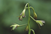
inflorescence - whole - unspecified |
|
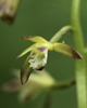
inflorescence - lateral view of flower |
|
inflorescence - frontal view of flower |