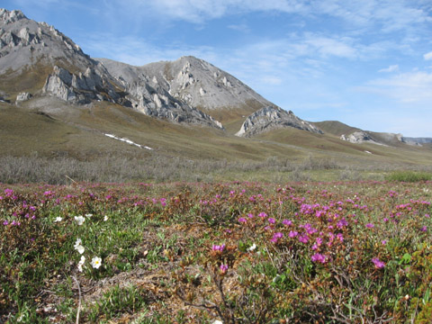
Tundra near Mancha Creek, Arctic National Wildlife Refuge, Alaska (c) 2006 Dallas Smith
Bioimages home (click on an image to enlarge)
view
this page in its intended navigation context
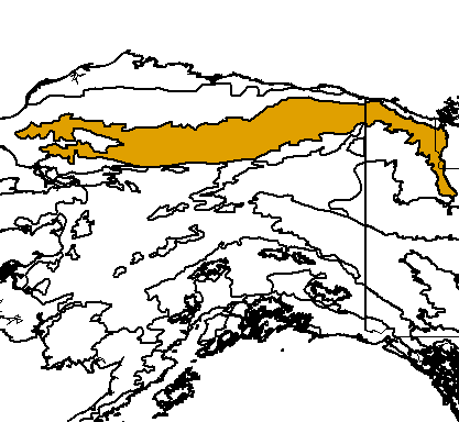
Brooks-British Range tundra (WWF
ecoregion NA1108)

Tundra near Mancha Creek, Arctic National
Wildlife Refuge, Alaska
(c) 2006
Dallas Smith

Source of bioregions data:
Olson, D. M. and
E. Dinerstein. The Global 200: Priority ecoregions for global conservation. (PDF
file) Annals of the Missouri Botanical Garden 89:125-126.
Distinctiveness (1=highest,4=lowest): 3 (bioregionally
outstanding)
Due to the harsh mountain climate, vegetation is sparse. Caribou herds
migrate through the region via valleys. Top level predators are present.*
Conservation Status (1=most endangered, 5=most
intact): 5 (relatively intact)
The ecoregion is almost entirely intact except for two major highway corridors
that cross it.*
 Picea glauca (white spruce)
 | Abies lasiocarpa | (subalpine fir) |
 | Pinus contorta | (lodgepole pine) |
Some views from the ecoregion
near Mancha Creek, Arctic National Wildlife Refuge, Alaska


(left) Mancha Creek, (2nd and
3rd from left) scattered black spruce near the northern limit of trees, (4th
from left) animal (caribou?) trails up slope.
Photos taken on a trip
described in
Tennes-Sierran 38:3 (March 2007),
38:4,
and
38:5
that involved removal of a cabin at approximately 68.676913,-141.209679 and
ended on Joe Creek at approximately 68.974164,-141.459961
(c) 2006
Dallas Smith
hires hires hires hires hires hires hires
rock formations, near Mancha Creek, Arctic National Wildlife Refuge, Alaska


(c) 2006
Dallas Smith
hires hires hires hires hires
tundra, near Mancha Creek, Arctic National Wildlife Refuge, Alaska


(c) 2006
Dallas Smith
hires hires hires hires hires
near Joe's Creek, Arctic National Wildlife Refuge, Alaska


(left) Joe's Creek, (center)
tundra wildflowers, (right) arctic ground squirrel
(c) 2006
Dallas Smith
hires hires hires
caribou, near Mancha Creek, Arctic National Wildlife Refuge, Alaska


(lel
(c) 2006
Dallas Smith
hires hires hires hires hires hires
animals, near Mancha Creek, Arctic National Wildlife Refuge, Alaska


(left and center) arctic
ground squirrel, (right) Dall sheep
(c) 2006
Dallas Smith
hires hires hires
Peaks, Brooks Range, Alaska

Tundra can be seen in the valleys below the unvegetated peaks
(c) 2006
Dallas Smith
hires
South of treeline, Brooks Range, Alaska


Left: The southern slopes of the Brooks Range lie
at the northern limit of trees. In this area, permafrost lies near the
surface and disturbances in it can cause tree-toppling and crevasses. Right:
"The furthest north spruce tree on the Alaska pipline. Do not cut."
(c)
2005 Scott and
Ruth Bassett
hires
hires
North of treeline, Brooks Range, Alaska


Left: Shrubs with brown bear in distance (visible
in hires version). Center and Right: Few woody plants are present on the north slope of the
Brooks Range.
(c)
2005 Scott and
Ruth Bassett
hires
hires
hires
Unvegetated peaks, Brooks Range, Alaska

At the highest elevation, there is little or no vegetation on the rocky peaks. (c)
2005 Scott and
Ruth Bassett
hires
Snow covered peaks, Brooks Range, Alaska


(c) 2005
Natasha Sherman
hires
hires
* Ricketts, T.H., E. Dinerstein, D.M. Olson, C.J. Loucks, et al. (1999) Terrestrial Ecoregions of North America: A Conservation Assessment. World Wildlife Fund - United States and Canada. Island Press, Washington, D.C. pp. 337-340.
Except as noted, images copyright 2002-2011 Steve Baskauf - Terms of use