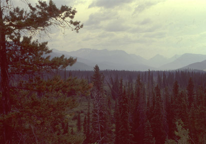
Forest between Watson Lake and Teslin Lake, northern British Columbia (c) 2005 Scott and Ruth Bassett
Bioimages home (click on an image to enlarge)
view
this page in its intended navigation context
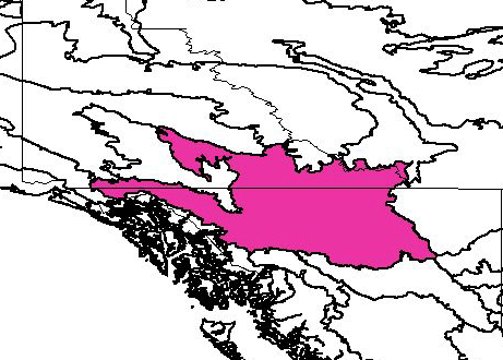
Northern Cordillera forests
(WWF
ecoregion NA0613)

Forest between Watson Lake and Teslin Lake, northern British Columbia
(c)
2005 Scott and
Ruth Bassett

Source of bioregions data:
Olson, D. M. and
E. Dinerstein. The Global 200: Priority ecoregions for global conservation. (PDF
file) Annals of the Missouri Botanical Garden 89:125-126.
Distinctiveness (1=highest,4=lowest): 1
(globally outstanding)
This ecoregion contains a large, intact population of large mammals, including
an intact predator=prey system.*
Conservation Status (1=most endangered, 5=most
intact): 3 (vulnerable)
About 85% of the ecoregion remains intact. Mining, logging hydroelectric
development, and transportation corridors are threats.*
 | Abies lasiocarpa | (subalpine fir) |
 Picea mariana (black spruce)
(c) 2004 Maurice J. Kaufmann
 | Picea glauca | (white spruce) |
 | Picea engelmannii | (Engelmann spruce) |
 | Pinus contorta | (lodgepole pine) |
Betula papyrifera (paper birch)
 | Populus tremuloides | (quaking aspen) |
Associated habitats
River and forest, northern British Columbia


left: Braided river, between Muncho Lake Prov. Park and Ft. Nelson, right: Ft.
Nelson River
(c)
2005 Scott and
Ruth Bassett
hires
hires
Forest, northern British Columbia

(c)
2005 Scott and
Ruth Bassett
hires
Liard Hot Springs, northern British Columbia


The warm microclimate caused by the hot springs provides an island of habitat
for plants normally found hundreds of miles to the south.
(c)
2005 Scott and
Ruth Bassett
hires
hires
* Ricketts, T.H., E. Dinerstein, D.M. Olson, C.J. Loucks, et al. (1999) Terrestrial Ecoregions of North America: A Conservation Assessment. World Wildlife Fund - United States and Canada. Island Press, Washington, D.C. pp. 358-360.
Except as noted, images copyright 2002-2005 Steve Baskauf - Terms of use